
At the July 25th, 2017 Johns Creek City Council Town Hall, multiple residents complained about the overwhelming material in the Comp Plan, stating that it is very hard to review. The 244-page report is heavy on images and non-essential details and is a monumental task just to review - even at a high level. Many of the before-and-after maps contain the same colors but represent different uses, creating confusion.*
Multiple suggestions were given to the Council and City Manager, both of whom agreed were reasonable and doable.
It has been 45 days since the City Manager & City Council agreed to the suggestions, and NONE of have taken place.
Though the City did not make it easier for you to understand, the JCP will!!
So what are the BIG Changes in the Draft?
1) A significant increase in Mixed Use Developments
Some of the biggest changes in the Comp Plan are the conversion of commercial parcels into Mixed Use Developments, at 3 levels of intensity.
Low-Intensity 3 stories in Height & 8 units per acre 2, the proposed locations:
Medium-Intensity Mixed Use Developments is described as 4 stories & 12 units per acre and is proposed on State Bridge Rd & Kimball Bridge Rd.
High-Intensity Mixed Use Developments is described as 5 stories & 16 units per acre. It is proposed on Barnwell Rd & Holcomb Bridge Rd and in Tech Park.
This Urbanism concept should come as no surprise to longtime JCP readers who can recall our post ‘Apartments Galore in the ‘District’. As a refresher, the City paid $250k to Urban Design Associates to devise plans to redevelop a large amount of private property into a mini-Buckhead. Residents' outrage thwarted the plans. It has now reappeared in the Comp Plan Draft.
It is absolutely stunning that with all the traffic & congestion, anyone in City Hall would consider increasing the density here.
So what is a driving force that seeks to allow Mixed Use near residential in Johns Creek? Developers and commercial property owners may desire higher density, mixed-use in order to maximize the value they can realize. The denser the parcel, the more monetary yield it can produce. Quite often during zoning hearings, developers request variances to make the development more financially viable. With Mixed Use allowed, developers can request to add-on another floor or two, to make the project even more lucrative.
2) Dividing & Diminishing Shakerag area
Another concerning proposed change is dividing the Shakerag area and moving a large part of it into the McGinnis Ferry Area.*** Doing so would increase the allowable density. Residents in that area prefer to remain in Shakerag with its current low density.
3) Lack of Historical Preservation
Within the Land Use Projects section, Historical Preservation was deemed NOT WARRANTED. This would have included incorporating preservation requirements into the Zoning Ordinance for identified historical/archeological resources and cemeteries and develop a historic preservation program.
The reason described for “DROPPING” is “due to the results of the Historic Resources Survey”.**^
Unfortunately, it appears the City and Consultants did not read the Historic Resources Survey Report that Johns Creek had conducted by UGA in 2012. On page 5, it states the following: “This basic, standard survey does not gather all the kinds of information needed in local preservation planning”.^ The report’s purpose was to identify buildings, sites, structures, and objects of historical, architectural, and cultural significance. ^
It is up to the municipality to formulate preservation of identified sites. Will they? Now is a good time.
4) Proposed New Road Along Cemetery – Inappropriately Located

The most offensive new road proposed, abuts the Macedonia Freed Slave Cemetery. As if it wasn’t desecrated enough, the Consultants and City Staff included the road in the draft plan.^* It is envisioned with potential redevelopment of 3 stories of mixed use.
5) Road Widenings
Several Roads are indicated in the plan for widening^^*. Some of these projects will take away the residential feel.
Millions have been spent on the sidewalks and median beautification on State Bridge Rd. Now it is slated for 6 Lanes as a TSPLOST project, and on the land use draft. Where will these lanes go? Will the beautiful medians be removed for more pavement or the sidewalks?
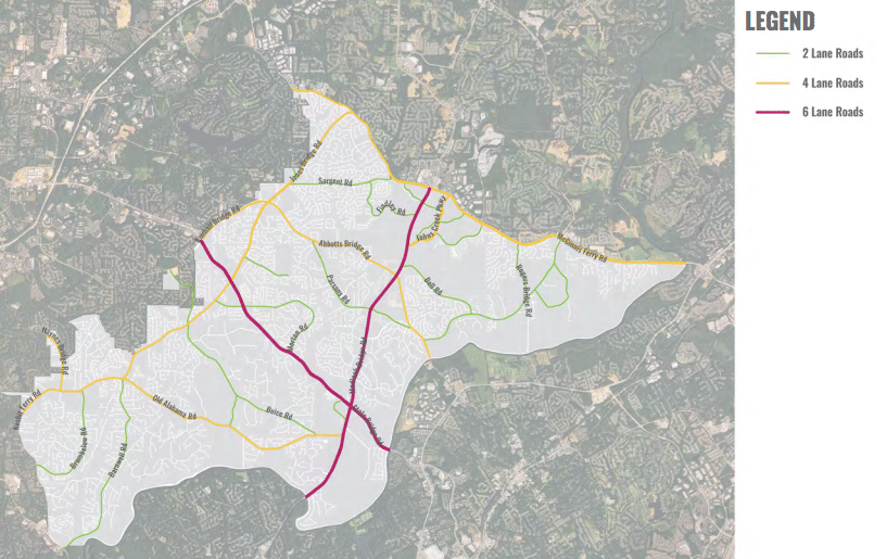
Proposed Roadways
6) Potential Roundabouts
The following were indicated as potential roundabouts.^**
September 15th is when Public Feedback ends, and the Comp Plan moves forth to Atlanta Regional Commission (ARC) unless City Council extends it.
Provide FEEDBACK to City Council: [email protected]
-References
Source: City of Johns Creek


The current draft of the Comprehensive Land Use Plan has not been sufficiently vetted by the public. It's true that it is a very large amount of information and the ease of review is difficult at best. This document will guide development and zoning decisions for the next decade. It is too important to rush and we have to get it right.
At a time when we are being asked to approve road widenings throughout Johns Creek, it defies good sense that we are simultaneously considering higher density development. High density and greater traffic congestion are correlated. As our roads are already maxed out, isn't it appropriate to state what should be obvious, "If you are in a hole, stop digging!"
This is frightening ! So the blue spot on the map is Rivermont Shopping Center at the corner of Barnwell and Holcomb Bridge Rds! If it is rezoned to Multi Use, we could see multi 5 story buildings going up there ???? This property backs up to the Colony and Village sections of Rivermont! Would these homeowners want something like this towering over their homes ?
"September 15th is when Public Feedback ends, and the Comp Plan moves forth to Atlanta Regional Commission (ARC) unless City Council extends it."
We must ask that city council extend the additional feedback period. More importantly, we must ask that our elected officials listen to the residents. Not just extend the period but provide a proposal based on resident's feedback and desires not just those of the select few.
We want traffic solutions and proposing more density hurts our traffic. The city has to address traffic and the Comp Plan as it stands today will exacerbate traffic. High density adds to traffic, service needs, infrastructure needs and overcrowding to our schools.
I have never heard anyone say that they want more density, more roundabouts, and more changes to the character of our city.
Write to all the city leaders using the email below. The Comp Plan is NOT acceptable as it is today.
Provide FEEDBACK to City Council: [email protected]
I would love more roundabouts.
... to move to a place with plenty of roundabouts. And don't forget to call Tom Black, he'll install one in your new home's driveway as well.
Issure - Did you provide any comments on the Comp Plan? It's been available for several months. Very few people have cared to comment and it is not because of time.
Everything has to be put on hold till we elect a NEW MAYOR, and get rid of Billboard Boder's cronies as well
I have no problem what so ever with a well designed, well laid out roundabout, however, the "mini-roundabouts" that we are currently being forced to use, to be quite blunt, S.U.C.K.!!!
Unless I missed something, our Mayor said earlier on this post, "In eleven years we increased transparency..."
This post also noted that our government agreed to modify the Comp Plan to make it easier to understand, i.e., more transparent. It has been over 45 days and nothing has been delivered by our highly paid consultants.
In absence of the revised/more transparent Comp Plan, I believe an extension is in order so citizens have an opportunity to make more informed comments. If not, then this represents another broken/empty promise from our government...
Why not tell the Mayor, City Council and the city manager your thoughts on the Comprehensive Plan? Posting on here will not help!
@Paul -
You can surely make any points during the Public Comments portion of our City Council Meetings. Just make sure you can do it in under three minutes, and hope that an aggregate of 30 minutes hasn't already been used.
Free speech and the right to be heard is limited in Johns Creek. See this excellent post that clearly identifies how our residents' ability to express their concerns in a public form has been severely restricted.
https://www.johnscreekpost.com/hot-button-issues-term-limits-free-speech/
The alternative of writing to our representatives does not guarantee any action, nor does it allow for transparent communication. Indeed, in most cases, it is the fast lane to being ignored.
The Comprehensive Use Plan has been a one-way street throughout the process. We are being fed a foregone conclusion without any meaningful opportunity to affect the outcome. Posting here as well as other social media platforms is a more effective method of educating and communicating.
Paul, I am quite sure that they all read the Johns Creek post. They make reference to it all the time.
If you have not read through this "draft", you need to. There are many unproven assumptions presented in this document. Some of the sources are weak at best. One cites traffic data on 141 as coming from Atlanta. Really?
Also, the document says
"TAX DIGEST"
• Johns Creek’s tax digest is primarily
residential, and while property
values are high, this does not
prove to be a sustainable source
of assets as the City’s liabilities
continue to grow
Does this City have a fiscal crisis on the horizon as was expressed a few years back as reasons to build a Central Business District?
What exactly does that statement mean? Who takes credit for including it, and do all the Council Members agree with that statement?
Can we talk about tax yield per acre? Is this being discussed and used to determine how much density we need to have a "sustainable source of assets?" Is this our new benchmark as to how our community is doing? Who decided to include that in the draft comp plan?
The city should just "pony up" and send out a simple flier telling the residents of each section what the proposed changes are. The City
wastes money on all kinds of baloney and salaries...this is important stuff..."Pony up " and mail out the fliers!
Brad Raffensperger was able to continuously communicate with his constituents via email when a Council member and continues to do so as our legislator. It is not a difficult process but requires true dedication to communication. Our present Council members and Mayor could easily do the same.