Comprehensive Land Use Plan Draft Update: New Timeline. At the City Council meeting Monday night, Community Development Director Sharon Ebert
gave an update to the Comprehensive Land Use Plan Draft. She has received feedback from over 200 residents. She requested Council to extend the timeline and create a second draft (to lower the density and make the document easier to read), which will be ready early 2018.
-
These changes are a result of the vocal residents who read our post published on Sept 9th:
Land Use Comp Plan being PUSHED Thru Despite Residents Concerns, in response to the lack of action from City Hall to implement reasonable suggestions to improve the readability of the document, and the understand the drastic changes proposed.
-
For historical context, on Sept 15th, we were contacted by the City Manager, regarding that post. Below is his email and JCP responses are in RED.
-
Dear Jennifer,
I noticed your posting about the comprehensive land use plan on your personal blog. I reviewed the information and found some factual errors and misleading statements included that I thought you would like to be made aware of so that you had the ability to correct the information.
-
1. “Land Use Comp Plan being Pushed Thru Despite Residents Concerns”
Comment: The title is misleading. The Comp plan is in its first rough draft form, has not been reviewed at a Council meeting by the Mayor and Council, has not had a public hearing and is not scheduled for a vote. The public process is just beginning.
Who here knew there would be multiple drafts and review processes?
No one. Please review your timeline on the connectjohnscreek.com website.
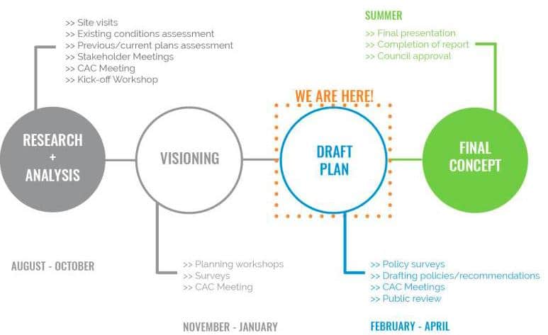
Clearly, this is not clear to anyone. It seems like Y'all are making this up as you go along. Also from the website, the LATEST Blog. Please note the date for public feedback is stated as Sept 15th.
It is being pushed thru despite concerns. Please review the above screenshots and the town hall July 25 discussion and make note of all the suggestions to improve the readability and understanding of this document. Where is the "better" before and after maps? Plenty of suggestions were given, and not implemented. So yes, this is getting pushed thru, particularly when you are NOT executing the recommendations of the Mayor, Council, and Residents.
Please provide a timeline/action line for the residents so that they know where we are in this process. For instance, if this in its first rough draft form, when is the 2nd rough draft going to be released? Will the residents have an opportunity to provide feedback again? How many drafts can we anticipate?
1. Some major points were missed:
* Major reduction in new residential development in all character areas
* No new townhomes in any residential character area, only single family detached
* Updated Comp Plan will result in a 65% reduction in the number of housing units compared to the current comp plan. (14,000 current and 5,000 proposed)
* Transitional areas in the current comp plan have been eliminated along with allowable mixed use in those character areas
* 91% of the future land use map shows no changes to existing land uses.
1. Mixed use development will be decreased
* Mixed use development is currently allowable in all C-1 zoning districts. The draft Comp Plan only allows for mixed use developments in a compressed area of Tech Park bounded by Medlock Bridge Road, Johns Creek Parkway and East Johns Crossing and some existing but not all retail shopping centers where walkability is desirable. This is a significant decrease in the amount of land where Mixed Use would be considered. Furthermore, the mixed use category has been further limited in the updated Comp Plan.
-
Where and what were they considering? (see highlighted)
-
1. Low Intensity Mixed Use –
* Medlock and State Bridge – The commercial areas located at this intersection are not listed for any mixed-use redevelopment.
-
Please view for the rendering potential redevelopment
Why is the CAC including sketches and renderings of properties in a rough draft if this is not the intent? Please see that they are removed from the next version of the draft, Since this is news there is a second version.
-
* A small area at Bell Road and McGinnis Ferry are currently designated in the 2008 comp plan for mixed use. No change in this Comp Plan update except it would be recommended for the lowest intensity mixed use.
-
-
- Please view the following pages and note the change for mixed use on the west side of Bell Rd at MGF.
1. High Intensity Mixed Use –
* Barnwell and Holcolmb Bridge is limited to the shopping center that fronts Holcomb Bridge Road and borders the City of Roswell.
* Only the much smaller core area of Tech Park is recommended for high intensity mixed use, not the whole area. The area recommended in Tech Park bounded by Medlock Bridge Road and JC Parkway south of East Johns Crossing
* The High Intensity Mixed Use density is lower than what is currently permitted in the Comp Plan for the Medlock Bridge Corridor Area which does not cap density, just height. The 16 units per acre recommendation is a reduction from what is currently built in the area and the height restriction is being recommended to go down from 8 currently allowed to 5 stories. Furthermore, the total land area allowed to be in High Intensity Mixed Use is considerably smaller than the Medlock Bridge Corridor Area.
-
Why must the CAC include any high intensity mixed use in our Comp Plan?
-
1. City’s current residential density is 1.6 units to the acre. The comp plan update will lessen the rate of growth compared to what would be allowed using the current Comp Plan. We have a very low residential density in Johns Creek compared to our neighbors, which is desirable and will not fundamentally change via this comp plan except to lower the rate of growth from our current path.
-
This is a false argument. Johns Creek already has more residents per acre than anyone around us. How will the new plan lessen the rate of growth?
-
Furthermore, residential density and commercial development are not the only factors that lead to increased traffic. Single entrance subdivisions and pass through traffic also contribute to traffic congestion. While you can argue that even one additional square foot of development or 1 unit of housing will exacerbate traffic, it is important to note that since the City’s incorporation, as shown below most of the existing density related to non-single family housing was created in the 1990s and early 2000s prior to the city’s incorporation. Assisted Living/Senior restricted housing has no impact on schools and have minimal impact on traffic compared to other uses. The growth in the number of apartment units is less than 1% per year and only included one apartment development. Townhomes units have increased by less than 1% per year. Townhomes will no longer be allowed under the updated Comp Plan.
I don't see where it is stated that townhomes are not allowed in the draft plan.
Please provide the data and rate of change of "pass-through traffic" over the last ten years. Examine your own demographic data. One of every two homes has school-age children, higher than neighboring communities by 50%. Non-rush hour traffic has seen the greatest increase in volumes because of this trend.
1. Dividing and Diminishing Shakerag
* The current Comp Plan allows for up to 3 dwelling units per acre for the Shakerag Character Area. The proposed Shakerag area reduces development to no more than 1 unit per acre. Some of the existing area in Shakerag was cut out and moved to McGinnis Ferry. It is true that those parcels would remain in the up to 3 units per acre category. If they were retained in the Shakerag area they would be lowered to the one unit per acre standard. Staff has received comments that keeping the area North of Bell Road in Shakerag and not moving it to McGinnis would be desirable. We are reviewing that recommendation with the CAC and staff is also reviewing that specific input received
1. Proposed new road along cemetery – inappropriately located
* There is no mixed-use development proposed at State Bridge and Medlock Bridge Road.
* The private drive was sketched as a concept that has not been reviewed by Mayor and Council. The idea was to use the existing drive as a new local public street to try to alleviate traffic congestion. The road (as sketched) would be no closer to the cemetery than the current private drive.
-
This is false, the road is north of the current driveway. I am happy to show you in person. Remove this and other items like this from the next Draft version, since there will now be a second draft.
-
1. Roundabouts
* The comp plan suggests areas where a roundabout should be studied further if it would help move traffic and improve safety. The Comp Plan update is not recommending that the roundabouts be installed. It is recommended that they be studied further.
-
Please read the title. Potential Roundabouts. Isn't the comp plan the right place for recommendations(policy more or less) for roundabouts? Why was this included?
-
1. Public comment
* We are not ending public comment on September 15th. We will accept and consider all comments up to the point that the plan is approved by Mayor and Council. The citizens of Johns Creek will continue to have ample opportunity to review the draft plan and provide feedback. The draft plan and all of the information regarding the plan and the planning process are available at www.connectjohnscreek.com<
http://www.connectjohnscreek.com/> and the draft plan has already been available for review since June 7, 2017.
-
Please review the Town Hall video (link above) from July 25th. This was last time the council as a body discussed when public comment ended for the draft. Has there been any discussion on the dais since then extending that date? No.
Are you indicating that there has been roving meetings or consensus obtained without a public meeting to move the Sept 15th date?
-
* Additionally, a public hearing will be conducted and Council will weigh in on the draft and its future drafts prior to the draft being sent to the Atlanta Regional Commission (ARC) for their review. This public hearing has not yet been scheduled. The ARC’s review typically takes 90 days. A final draft will then be issued for another review by the public before going before the Mayor and City Council for review and approval. All of these phases will have public comment encouraged.
* The City is required by law to adopt an update to the Comprehensive Plan by November 2018. We still have 14 and a half months until our deadline.
* There is no deadline for receiving public input and the City welcomes comments and suggestions at any time in any manner in which the public would like to present it to the City.
* We encouraged comments on the first draft by September 15th so that we could share these with the Citizens Advisory Committee and Mayor and Council and for considering these comments as staff updates the first draft into the 2nd draft which will be made available for public review and comment.
1. Additional thoughts:
* The five policy goals were not listed in your post. These are the key drivers of the whole comp plan:
i. Creating a city-wide multi-modal sustainable transportation network that reduces traffic congestion, increases intra-city mobility, and includes complete streets, cart, bike and pedestrian pathways that connect neighborhoods to schools, parks, shopping centers, and institutional destinations;
ii. Creating an identity for the city that guides future development while preserving its residential neighborhoods and exceptional quality of life;
iii. Expanding the city’s economic base to retain and attract high tech industries while protecting residential home values;
iv. Providing superior recreational and cultural activities throughout the city, and
v. Developing tools to implement the goals, including developing a Unified Development Code with architectural and site design standards.
* The link to the 1st draft of the comp plan is a <
http://www.connectjohnscreek.com/> if your readers want to see the actual document and all of the other documents and items related to the comp plan.
-
Please review the website yourself, to see where you are stating inaccurate information about the timeline & Sept 15th.
Also go through the comp plan draft again. Notice an important word missing? DRAFT! Every page should be watermarked with Draft on it. Now you will need to include which draft version. This is amateur hour, and it is costing the taxpayers money and time.
Finally, can you please explain why the City is developing plans for a private property?


Why is the city treating us like mushrooms ? Feeding us a bunch
Of crap and keeping us in the dark !
We are not mushrooms .
D&D,
You appear to be a mushroom by self-selection. Every meeting of the Citizens Advisory Committee has been streamed online, has been and currently is available for view on the City's website. If you REALLY want to help and get involved attend or watch any of the many workshops and meeting sessions that have been held for the past year. Hiding in the weeds and taking potshots at those that spend their time to make Johns Creek a better place should best be left to the "professionals" that run this blog.